Updated: August 9, 2026 • By Santorini Dave
The Amalfi Coast runs along the southern side of Italy’s Sorrentine Peninsula, from Positano in the west to Vietri sul Mare near Salerno in the east. The main towns, west to east, are Positano, Praiano, Amalfi, Atrani, Minori, Maiori, Cetara, and Vietri sul Mare, with Ravello high in the hills above Amalfi. Sorrento, Capri, Naples, and Salerno are not part of the Amalfi Coast, but they are important gateways and are included on the maps below.
Amalfi Coast Towns Map
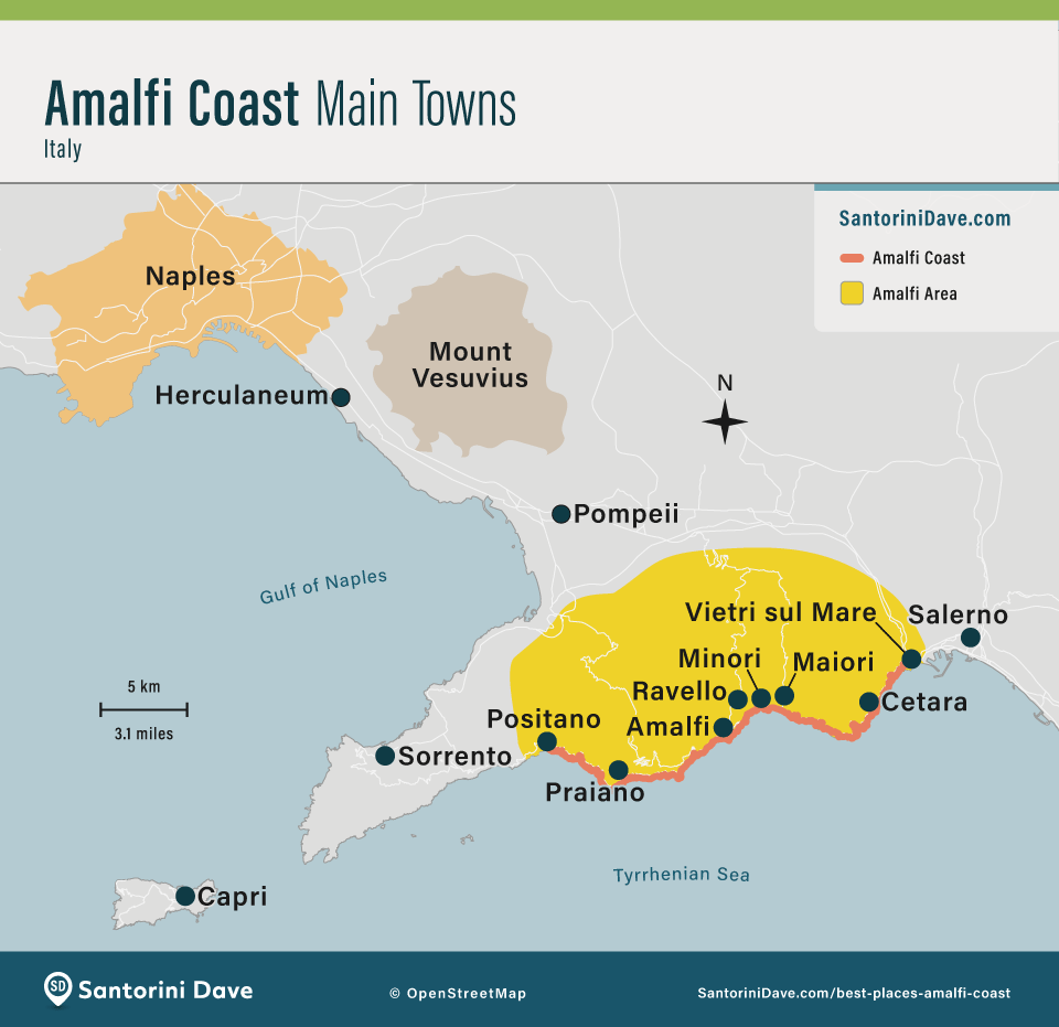
Sorrento and Salerno are gateways rather than proper Amalfi Coast towns. Ravello sits high in the hills above Amalfi and Atrani.
Best Places to Stay on the Amalfi Coast
- Best Luxury Hotels on Amalfi Coast
Il San Pietro (Positano) • Santa Caterina (Amalfi) • Palazzo Avino (Ravello) - Best Hotels for Families on Amalfi Coast
Eden Roc (Positano) • Luna Convento (Amalfi) • La Valle delle Najadi (Vietri sul Mare) - Best Hotels for Couples on Amalfi Coast
Palazzo Avino (Ravello) • Il San Pietro (Positano) • Casa Angelina (Praiano) - Best Boutique Hotels on Amalfi Coast
Villa Magia (Positano) • Casa Angelina (Praiano) • Palazzo Murat (Positano) - Best Beach Resorts on Amalfi Coast
(hotels with their own natural, sandy beaches)
Cetus (Cetara) • Marincanto (Positano) • Borgo Santandrea (Amalfi) - Best Cheap/Midrange Hotels on Amalfi Coast
La Tavolozza Residence (Positano) • La Valle delle Najadi (Vietri sul Mare) • Parsifal (Ravello)
Amalfi Coast Regional Map
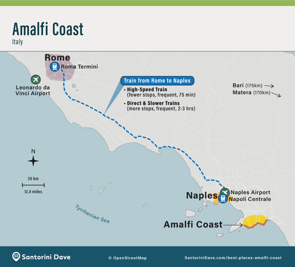
The Amalfi Coast is south of Naples on the southern side of the Sorrentine Peninsula. Sorrento is the main gateway from the west, Salerno from the east, and Capri lies offshore across from the peninsula.
My Tips for the Amalfi Coast
- 1. Download Offline Google Maps
Cell service is unreliable on the winding coastal roads. Before you leave home, search “Amalfi” in the Google Maps app, tap the three-dot menu, and select “Download offline map.” Adjust the frame to cover the entire area from Sorrento to Salerno (including Capri). Tip: Star your hotel, ferry docks, and trailheads while you have Wi-Fi. Many hotels are hidden down pedestrian alleys that are difficult to find without precise GPS. - 2. Sorrento is the Western Gateway
Sorrento sits northwest of the Amalfi Coast proper. It has direct Circumvesuviana trains to Pompeii and Naples, plus ferries to Capri, Positano, and other coastal destinations. It is flatter and more walkable than the coastal towns but lacks the dramatic cliffside scenery. - 3. Positano is Vertical
Maps look flat; Positano is not. The town is built almost entirely vertically. Your hotel might be 400 steps up from the beach, which is physically demanding. It has the best nightlife, luxury hotels, and photogenic views on the coast, but expect lots of stairs and steep streets. - 4. Amalfi Town is the Transport Hub
Located near the geographic center of the coast, Amalfi is the main hub for buses and ferries and my favorite base for exploring without a car. The tiny village of Atrani is just a 10-minute walk around the headland. - 5. Ravello is High Above the Sea
Ravello is located inland on a mountain, not on the water. It has no direct beach or ferry access; take a bus or taxi down to Amalfi for boats and beaches. It is sophisticated, quiet, and famous for its gardens and summer music festivals. - 6. Praiano for Sunsets
Praiano’s west-facing position gives it some of the best afternoon sun and sunset views on the coast, while much of Positano falls into shadow earlier. It’s quieter than Positano but spread out along the main road. - 7. Maiori & Minori are Best for Families
These are two of the easiest Amalfi Coast towns for families, with flatter centers and waterfront promenades. Maiori has the coast’s longest and most spacious main beach; Minori is smaller, prettier, and especially good for food. Both are easier with young children than Positano or Ravello. - 8. Salerno is the Southern Gateway
Salerno sits at the eastern end of the coast and has a major train station with high-speed connections to Rome and Naples. It feels more like a working Italian city than a resort town, with good restaurants, lower hotel prices, and easy ferry connections along the coast. - 9. Use Ferries When Possible
On a map, the coastal road (SS163) looks like a short drive. In reality, it is narrow, winding, and frequently congested. When ferries are running, choose them over the bus for travel between Positano, Amalfi, and Salerno. They’re faster and more comfortable and avoid the worst SS163 traffic. Buses remain essential for Ravello and for travel when ferries aren’t operating. - 10. Don’t Drive Unless You Need To
Parking is scarce and expensive, and many town centers have restricted traffic zones or are largely pedestrianized. In peak periods, the SS163 also uses odd/even license-plate restrictions on designated dates and hours, so check the current rules before driving. If you do rent a car, confirm parking with your hotel before booking.
Amalfi Coast Driving Map
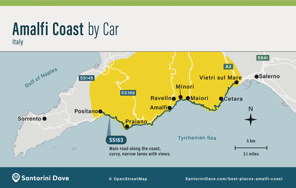
The SS163 coastal road connects the Amalfi Coast towns, but distances on the map are deceptive. Traffic, narrow roads, buses, and limited parking make driving much slower and more difficult than it looks, especially from late spring through early fall.
Amalfi Coast Ferry Map
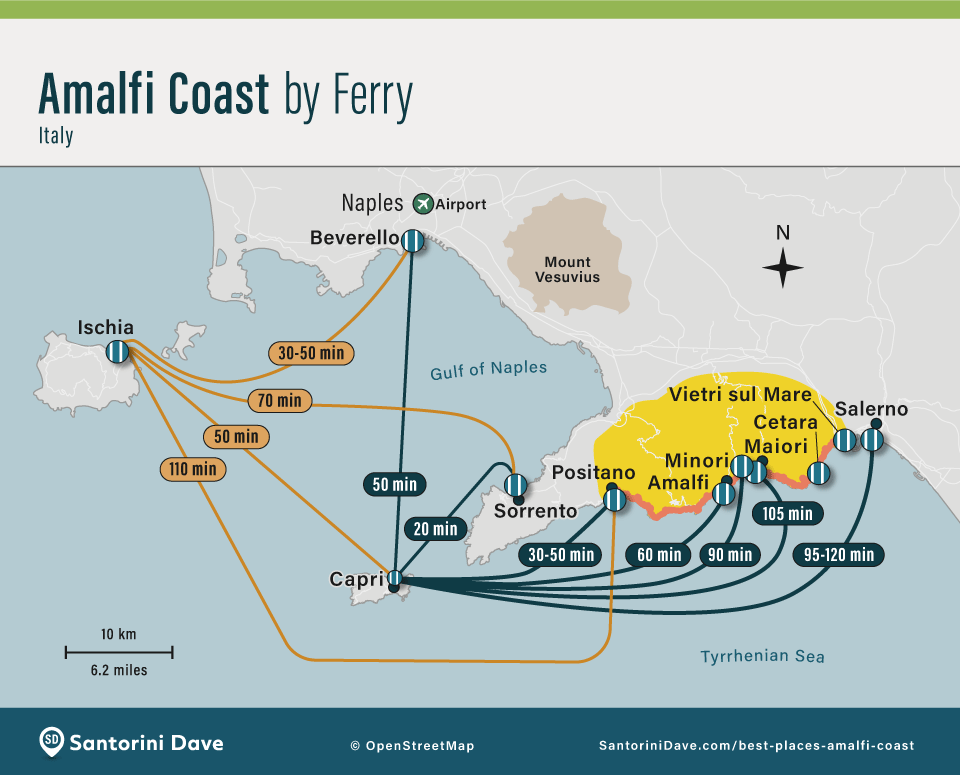
Ferries are the easiest way to travel between many coastal towns when they’re operating, with Amalfi, Positano, and Salerno the most useful hubs. Service is strongest from spring through fall and can be disrupted by rough seas. Ravello has no port and requires a bus or taxi connection from Amalfi.
Amalfi Coast Train Map
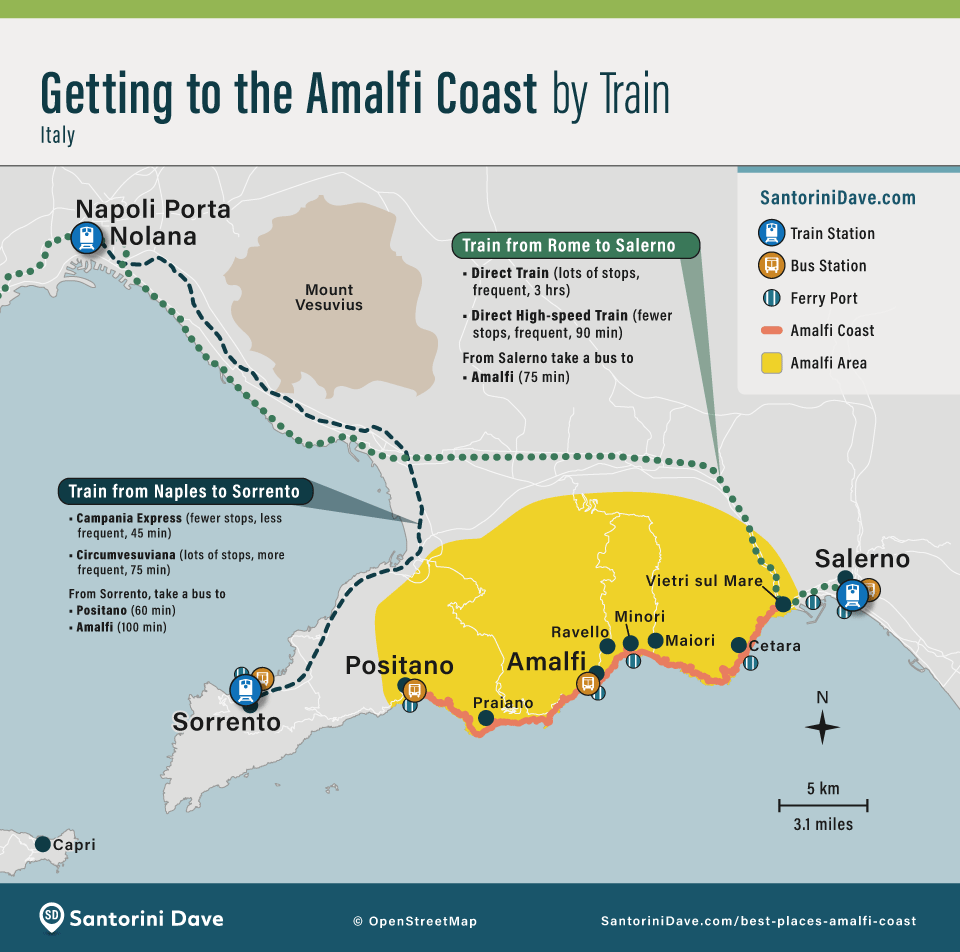
There is no train line along the Amalfi Coast. Sorrento is the useful rail gateway from Naples for Positano and the western end of the coast. Salerno has high-speed rail connections and is the easiest train gateway for Amalfi and the eastern end.
Buses follow the coast from Sorrento through Positano and Praiano to Amalfi, and from Amalfi east through Minori and Maiori toward Salerno. Amalfi is the main bus hub and the transfer point for Ravello. Buses are useful year-round but can be slow and crowded in summer.
Path of the Gods Hiking Map
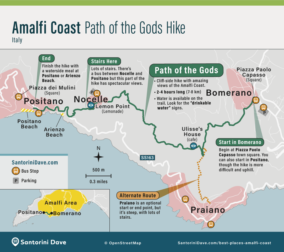
The Path of the Gods is the Amalfi Coast’s best hike. The most popular route starts in Bomerano, high above the coast in Agerola, and runs west toward Nocelle above Positano. Hiking in this direction keeps the best coastal views in front of you.

About Santorini Dave